Wildlands plays a role in the 2023 NADO Award for Land of Sky Regional Council Project

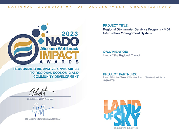
The Land of Sky Regional Council (LOSRC) was recently awarded the 2023 NADO Aliceann Wohlbruck Impact Award for their project “Regional Stormwater Services Program – MS4 Information Management System.” The system was configured by Wildlands Engineering for LOSRC who funded and deployed this technology across multiple jurisdictions (Fletcher, Woodfin, Black Mountain, and Weaverville) for a fraction of the cost of typical management systems. It provides a low-cost alternative for smaller jurisdictions that do not use a digital asset management system for stormwater infrastructure.

The MS4 Information Management System is a low-cost alternative for smaller jurisdictions that do not use a digital asset management system for stormwater infrastructure. The MS4 Information Management System is an integrated documentation system for stormwater outfall inspections – both for identifying maintenance needs and for discovering possible illicit discharges; it can also be used for reporting.

The system is built on the esri GIS platform and centrally hosted and managed in ArcGIS Online (AGOL) by LOSRC. Proactive stormwater management is crucial to protecting water quality. LOSRC aims to map all the stormwater systems in the region and uses this system to provide a simple field-based mobile app to support inspections and maintenance. Communities can access the platform anywhere and it’s designed to be used on a tablet or smartphone in the field. The system consists of inspection forms (ArcGIS Survey123), a locationally aware mobile map (ArcGIS Field Maps), and the stormwater system inventory (AGOL). Surveys documenting illicit discharges and/or high priority storm maintenance requirements will trigger an email to the corresponding town public works director. Survey123 also consists of a web-application that provides a data dashboard to review and report on the information collected with the inspection forms.

In the future, the system can be expanded for additional MS4 permit requirements (e.g., SCM inspections, catch basin cleaning, facility, and pavement management).

Wildlands looks forward to providing more quality, accessible, and functional online mapping tools for future clients!

#NADO #award #wildlandsengineering #stormwater #waterquality #ArcGIS #mappingtools #landofsky #ashevillenc #GIS

PROJECT SPOTLIGHT: Southside Community Stormwater Improvement Project

Since 2019, Wildlands Engineering (Wildlands) has been working on several green infrastructure project initiatives with our long-time partner RiverLink, a watershed group with the mission of promoting the environmental and economic vitality of the French Broad River and its watershed. Wildlands recently completed the Central Asheville Watershed Restoration Plan for Riverlink, which consisted of project identification and developing an interactive watershed plan. Within the watershed plan, projects were identified in multiple subwatersheds, including Nasty Branch which runs through the Southside Community. In the 1960s and 1970s, this and other nearby black communities were negatively impacted by urban renewal projects, which left a profound impact on the social structure and well-being of the community.

Over 1300 businesses and homes were lost from the Southside Community between the 1960’s and 1970’s.


Among the many projects identified, one stood out for its apparent need of creating a more functional space, safe environment, and resilient infrastructure at the Erskine Apartments – located along Livingston Street in the heart of Southside. The watershed plan identified proposed activities to target a drainage issue in the cul de sac on Water Street where water was seeping onto the road resulting in a bad odor and unsafe conditions, particularly in winter.  After further evaluation of the site and its contributing drainage and infrastructure, a multifaceted project was proposed to address multiple community needs as well as provide stormwater management to improve water quality in Nasty Branch.

In addition to the drainage issue, concrete stormwater swales and corrugated metal pipe systems from the original apartment construction in 1969 were failing, a powerline behind residences was very low to the ground creating an unsafe feeling environment, and areas of dense invasive vegetation created unusable spaces and consumed native trees and vegetation. Discussions with community leaders, meetings in the park, and door to door efforts lead to a list of community needs and desires that were assembled into a cohesive improvement plan to address as many considerations as possible.

Wildlands helped prepare technical information for grants to fund the project. Multiple entities contributed funding to the project including the apartment owner, the Asheville Housing Authority. The project used stormwater control measures called regenerative stormwater conveyance (RSC) channels to replace pipe and concrete ditches. These incorporate sand-based media to provide additional water quality treatment. Rain gardens and a stormwater wetland were implemented to capture parking lot and rooftop runoff; a french drain routed subsurface flow into the stormwater system to resolve road seepage; a power line relocation addressed the low overhead line; and trails and sitting areas for contemplation and to honor lost loved ones were incorporated into the project. The paths and a bridge over the RSC channel connect kids and community members to the nearby park, community center, school bus stops, and other nearby destinations. For more information, visit RiverLink’s Project Page »


Conserving Eastern Hellbender habitat at Wildlands Engineering’s Falcon Mitigation Site

North Carolina is home to one of the largest aquatic salamanders found in the United States, the Eastern Hellbender (Cryptobranchus a. alleganiensis). The Eastern Hellbender can grow to be more than two feet long and is found in perennial streams with fast flowing, cool, and clear water. Adult hellbenders spend most of their life under large, flat rocks that shelter them, whereas larval and juvenile hellbenders hide beneath large rocks and under small stones in gravel beds. Fine sediments from eroding stream beds and banks can harm these key habitats for this unique species. The Eastern Hellbender is currently listed as a US Federal Species of Concern (FSC) and a North Carolina Special Concern (NCSC).


Wildlands is currently working alongside state and federal agencies to provide ecological and water quality improvements at our Falcon Mitigation Site located in the western part of North Carolina. The streams within this mitigation site are part of a natural area rated as ‘high’ functioning by the NC Natural Heritage Program due to the richness of aquatic species it supports. Both Wildlands and the North Carolina Wildlife Resources Commission (NCWRC) noted the potential benefit of performing a restoration project within this important stream community.  To specifically benefit Eastern Hellbenders, Wildlands coordinated with NCWRC and conducted Eastern Hellbender surveys, as well as eDNA sampling during the design phase at the Site. Snorkeling within project streams was done to investigate existing habitats and try to identify any existing populations. Results from the study did not identify individual species within the project limits; however, a positive environmental DNA (eDNA) sample was recorded at the downstream end of the project which indicates that there is at least one animal within less than 1 km upstream from this point. Wildlands discussed areas that should be protected with NCWRC and is implementing species aimed habitats using large flat boulders to provide additional nesting areas within the channel post construction.


Through our restoration efforts, Wildlands will restore and enhance over 5,700 linear feet of stream by excluding livestock, creating stable stream banks, restoring a forest in agriculturally maintained buffer areas, and restoring riparian habitat. The site will also be protected in perpetuity by a 15.5-acre conservation easement. These actions will reduce fecal, nutrient, and sediment inputs to project streams, and ultimately to Cartoogechaye Creek and the Little Tennessee River, as well as reconnect instream and terrestrial habitats on the Site. Habitat and water quality are important factors for hellbender survival rates as they breathe entirely through their skin and cannot tolerate high sedimentation rates or low dissolved oxygen levels. Changes in watershed land use and streamside management have been the primary factor negatively impacting this species. During construction Wildlands and the contractor will be especially careful and observant for animals when working in the channel and relocate “out of harm’s way” per NCWRC guidance.


Wildlands is excited to be a part of this conservation effort for the Eastern Hellbender!


  • NCWRC snorkeling for Eastern Hellbenders while Wildlands employees collected GPS location data at the existing Falcon Mitigation Site.


Sources:
USFWS: https://www.fws.gov/species/eastern-hellbender-cryptobranchus-alleganiensis-alleganiensis
NCWRC: https://www.ncwildlife.org/Learning/Species/Amphibians/Eastern-Hellbender

Contacts at NCWRC: Lori Williams and Andrea Leslie


Wildlands Engineering continues to protect the dwarf-flowered heartleaf

In April of this year, Wildlands’ Double Rock Mitigation Project wrapped up construction, completed by Wildlands Construction. Located in the Catawba River basin, a unique aspect of this project is the presence of a rare species of plant called the dwarf-flowered heartleaf (Hexastylis naniflora)!


The dwarf-flowered heartleaf species is only found in several counties across North and South Carolina and is currently listed as threatened under the Endangered Species Act. However, in 2021, the USFWS proposed to de-list it. When the dwarf-flowered heartleaf was initially put on the endangered species list in 1989, there were only 24 known populations, distributed across North and South Carolina. Since then, through the combined efforts of various non-profits, land conservation organizations, and private landowners, the dwarf-flowered heartleaf has made a tremendous comeback. There are currently over 120 known populations, of which several of these sites are thriving with more than 1,000 plants, many are found on protected conservation lands.


Wildlands has had the opportunity to partner with many organizations, as well as private landowners, to create, implement, and preserve these stable habitats for endangered species such as the dwarf-flowered heartleaf. The organizations that have played a key role in conserving this species are: Foothills Land Conservancy, Catawba Lands Conservancy, The Nature Conservancy, National Park Service, Broad River Greenway, North Carolina Department of Transportation, Duke Energy, private landowners, State of North Carolina.


In 2023, Wildlands scientist identified and delineated the dwarf-flowered heartleaf population alongside USFWS within our project area. Wildlands worked closely with Wildlands Construction team to avoid any impacts to the population and conserve 3 acres of the dwarf-flowered heartleaf population and habitat that will be protected in perpetuity within the conservation easement. Wildlands is thrilled to be a part of the dwarf-flowered heartleaf’s conservation effort through the implementation of the Double Rock Mitigation Project.

Source: https://www.fws.gov/story/2021-04/proposed-delisting-dwarf-flowered-heartleaf


PROJECT SPOTLIGHT: McClure’s Bog Preserve Project

McClure’s Bog, a candidate for inclusion in the Mountain Bogs National Wildlife Refuge, is a French Broad River Valley Bog subtype and host to a suite of unique plant species and wildlife habitat and characterized by low nutrient groundwater-driven hydrology. Similar areas once existed in an extensive patchwork throughout the upper French Broad River Valley bottoms. Land use conversion practices, as well as changes to fire and other natural disturbance regimes, have severely impacted these features and in many cases eliminated them from the landscape. McClures Bog is one of several remnant areas with sustained populations of the unique species representative of this bog subtype. In recognition of this, McClures Bog was purchased for protection years ago, along with an adjacent natural stream corridor, by The Nature Conservancy (Conservancy) and the Natural Heritage Program of North Carolina (NC NHP). The bog has been, and continues to be, extensively managed by The Conservancy to preserve, and improve the sustainability of the species and habitats present.


The restoration project was constructed in the winter of 2019-2020 by South Core Environmental with oversight by Wildlands. The tiered wetland basins treat more than 1.5” of rainfall from the watershed, reduce surface runoff and nutrient and other pollutants to the bog, increase infiltration and create a more natural hydrologic regime and route high flows around sensitive areas of the bog. The site was treated for non-native invasive species prior to construction and planted post-construction with a robust and diverse suite of herbaceous, shrub and tree species to mimic other similar natural landscapes in the area. Post-project hydrologic monitoring and thermal groundwater investigation by University of North Carolina at Asheville (UNCA) has verified that the project successfully reduced stormwater inflows to sensitive plant areas and eliminated surface water runoff during most rainfall events.


The project was funded by the National Fish and Wildlife Foundation. The Conservancy and Wildlands lead a robust design and stakeholder team and process to execute the project. This team included Peak Hydrogeologic (groundwater testing), Joe Pye Ecological Consulting & Nursery (native plant and habitat restoration), KD Ecological (invasives plant management), US Fish & Wildlife Service, NC NHP, the US Army Corps of Engineers, NC Division of Environmental Quality (DEQ), Henderson County, Conserving Carolina, RiverLink, and UNCA Professor Jeff Wilcox and his students. Wildlands was the project manager and design-build lead, completing gage analysis, hydrologic and hydraulic modeling, visualization graphics and stakeholder coordination, stormwater design, permitting and adaptive management components and assisting with planting plans, invasive species removal scoping, and grant reporting.


Plant photos were taken by Emily Israel, Stewardship Coordinator for Wildlands, who was involved in invasive species management at McClure’s Bog under a prior engagement. Emily is dedicated to protecting North Carolina’s natural resources and land stewardship by contributing invaluable work to the conservation sector.


PROJECT SPOTLIGHT: Carolina Crossroads Permittee-Responsible Mitigation Project

Located in the heart of South Carolina, the Carolina Crossroads I-20/26/126 Corridor Improvement Project (a.k.a., Malfunction Junction makeover) is the number one interstate improvement priority for the state of South Carolina (https://lnkd.in/euFJQc2). Construction of the Carolina Crossroads project requires unavoidable impacts to waters (of the U.S.) under the jurisdiction of the U.S. Army Corps of Engineers as regulated by Section 404 of the Clean Water Act. The South Carolina Department of Transportation (SCDOT) evaluated multiple mitigation alternatives to offset aquatic resource impacts. The mitigation option that SCDOT selected has offset impacts through the restoration, enhancement, and protection of more than 80,000 linear feet of stream and the protection of more than 8.6-acres of wetlands. This large-scale and unique mitigation project will also protect more than 2,600 acres of land adjacent to the South Carolina Department of Natural Resources’ Belfast Wildlife Management Area, providing future public use and wildlife management benefits.


Wildlands led site identification and acquisition, mitigation plan development, natural channel design, generation of construction documents, and construction oversight of the restoration and enhancement activities. Due to the size of the mitigation project and this project serving as the largest stream mitigation project undertaken by the SCDOT, mitigation development was a collaborative effort among multiple project partners including SCDOT, HDR, Open Space Institute, Wildlands and members of the regulatory community. The size of the project site, and availability of on-site resources, allowed Wildlands to critically evaluate on-site materials and maximize the beneficial re-use of native and natural materials during construction. This practice reduced the client’s cost by reducing material import, maintained native characteristics through the reuse of available materials, and facilitated the primary objective of natural channel design. During construction, Wildlands utilized ArcGIS Online to communicate project status with key stakeholders. The contractor completed construction activities at the mitigation site in early 2022 and Phases 1 and 2 of the Malfunction Junction makeover are underway. Wildlands is currently providing post-construction monitoring services.


PROJECT SPOTLIGHT: Hendersonville Multi-Area Streambank Restoration Project

Wildlands recently completed the Hendersonville Multi-Area Streambank Restoration Project, which involved 11,000 linear feet across 13 sites on Mud Creek, a state listed 303(d) stream.  Funded by NCDEQ as a City Green Infrastructure Project, Wildlands partnered with Kee Mapping and Baker Grading to take this large, multi-phased project from initial feasibility through construction and monitoring.  Project highlights included:

  • The largest of the 13 sites was designed as a model/pilot project for urban stream and floodplain restoration. Receiving runoff from a  Walmart, apartments, and I-26, the stream was overly wide and eroding.  The design and construction resestablished floodplain connection using native materials for fish habitat structures as well as grade control.
  • Wildlands used ArcGIS online (AGOL) as: a communication tool between staff, the landowners, and the City; to document construction progress and survey; and for monitoring required by NCDEQ and Corps of Engineers.  Wildlands’ Senior Environmental Scientist Scott Gregory, GISP notes that, “Using AGOL allowed us to efficiently track all data through successive project stages.  All data, from initial landowner requirements to construction changes, was organized geospatially throughout the project and available with just a click.”  Check out screenshots from the AGOL application, below.


  • Real-time easement acquisition tracking by the City and stakeholders prior to project implementation

American Bittern sighting at Chantilly Ecological Sanctuary at Briar Creek

The American Bittern (Botaurus lentiginosus) is a medium-sized, wading bird in the heron family. They are often found in the marshy areas along side of lakes and ponds. This particular American Bittern spent the past winter in one of the small retention ponds at our Chantilly Ecological Sanctuary in Charlotte, NC. The bird was first seen November 11, 2020 and wintered through April 25, 2021. During this time frame, it was spotted over 70 times! These birds typically prefer the coast, but this special bird decided to winter in the city. This is a success story for Chantilly and a point of pride for Wildlands!


Check out the photos below taken by Patty Masten, along with the eBird map showing all historical records for American Bittern in the county. Note, the red circle on the map marks the Chantilly location.


Together, Wildlands Engineering and Wildlands Construction restore the Critcher Brothers Mitigation Site

We are thrilled to share this video that captures the synergy between Wildlands Engineering and our recently created construction company, Wildlands Construction. The Critcher Brothers Mitigation Site is a Wildlands-owned mitigation bank in the Yadkin River Basin of North Carolina. Approximately 21,000 cool stream credits will be delivered through stream restoration, enhancement, and preservation in a rural area historically used for cattle and agriculture. Construction was completed in 2021.

Unique ‘Pink Sundew’ plant spotted at Wildlands‘ Devil’s Racetrack Mitigation Site

This spring, Wildlands’ land stewards found a new population of pink sundew (Drosera capillaris) within a restored wetland at our Devil’s Racetrack Mitigation Site.  The pink sundew is a carnivorous, perennial plant found in pine savannas and wet, peaty areas. They are low-lying plants with rounded traps of sticky, tentacle-like leaves to hold their insect prey. This specimen was the first such sighting at the site and is also believed to be the first county record of the species (LeGrand et.al., 2021). Prior to restoration, the site was in agricultural production for decades.  Seeing this plant recolonize after so many years in agriculture is truly remarkable!

The Devil’s Racetrack Mitigation Site successfully reached the close-out milestone in August 2021 and is now in long term stewardship.

Source: LeGrand, H., B. Sorrie, and T. Howard. 2021. Vascular Plants of North Carolina [Internet]. Raleigh (NC): North Carolina Biodiversity Project and North Carolina State Parks. Available from https://auth1.dpr.ncparks.gov/flora/index.php.