
Urban Growth and Flood Resiliency: Navigating Environmental and Social Challenges in Urban Settings
Wildlands is embarking on a series of Flood Resilience articles that delve into flood-resilient projects’ social and environmental challenges and opportunities. This article specifically focuses on urban landscapes, the backdrop for some of our society’s most pressing challenges and promising opportunities.
With all the benefits of urban development, there are various environmental and infrastructure management challenges, intermingled with social challenges that all present as important considerations in our environmental restoration, recreational, and community enhancement work. They range from increased risk of flooding to impacts on water quality and aquatic habitat degradation and displacement. However, as cities continue to expand and redevelop, the need for effective flood mitigation, water quality, and ecological restoration solutions to manage these development impacts is gaining an increasing amount of recognition. These solutions, when implemented, can bring about a positive change, improving the environment and our quality of life, instilling hope for a more resilient and sustainable future.
The leadership of our municipal, state, and federal agencies and non-profit partners is instrumental in implementing nature-based solutions. Their commitment to the mission of their respective organizations sets the stage for project success. These entities oversee the planning, implementation, and long-term maintenance of projects, ensuring quality design and implementation. While many of our projects are on working (agricultural) lands, our urban projects hold a special place. They offer an opportunity to work and make a difference in our own communities and watersheds.
Our work on nature-based solutions to flood resiliency and related opportunities is a testament to collaboration. It’s a patchwork of collecting and fitting the fabric of our natural and social ecosystems. As we gather the pieces, we rely on proven practices for natural and engineered systems, creativity, community and partner input, and persistence to weave a pattern together.
There are many techniques for restoring and enhancing the function of natural, flood-resilient infrastructure. Wildlands has had the opportunity to be a part of multiple urban projects that have promoted flood resiliency. Some of these projects are highlighted below:
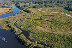
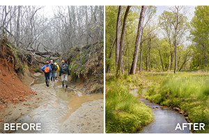 Reedy Creek Stream Restoration Project, Charlotte, NC
Technique: Reconnect the stream to its floodplain to increase flood storage capacity
Reedy Creek is an example of a watershed-scale restoration project that restored streams, floodplains, and wetlands on the mainstem of Reedy Creek and its tributaries within the Reedy Creek Nature Preserve. This watershed-scale approach allowed Wildlands’ designers to raise and reconnect streams with their natural valleys. Stream, floodplain, and wetland restoration are flood resiliency practices that reduce downstream runoff by increasing flood storage in natural stream floodplains. Streams that have been historically straightened for farming or land development are prone to downcutting. This straightened condition results in high-velocity flow, and the resulting deep channel is cut off from its natural floodplain storage. The problem propagates downstream, exacerbating the downcutting and channel erosion cycle, resulting in water quality impacts and filling lakes and reservoirs with sediment. Streams with a good floodplain connection access this flood storage during routine and large events. When floodplains contain natural vegetation, they are resilient to flooding, and aquatic and terrestrial plants and animals rely on flooding to support critical processes in their life cycles.
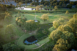 Chantilly Ecological Sanctuary, Charlotte, NC
Technique: FEMA buyout; implementation of Best Management Practices (BMPs)
Before flood maps and consistently implemented regulations, or in areas along small urban streams with rapid development, many homes and developments were established in areas prone to flooding. While structural options exist to raise the foundation of homes that are subject to flooding, sometimes this is not an option. In cases of repeat flooding, economic losses, and life disruption, flood-prone buildings can be bought out and removed to end an unsustainable cycle. Under the FEMA flood mitigation buy-out program, Mecklenburg County purchased and removed flood-prone buildings from the Briar Creek floodplain, providing the opportunity to develop a community green space and incorporate stormwater quality retrofits and stream restoration. Wildlands designed over 4,400 LF of stream restoration and enhancement and two stormwater quality BMPs that provide pollutant removal benefits and are part of the restored floodplain of Briar Creek. This project converted a vulnerable, flood-prone site into a resilient area that provides downstream benefits while meeting community open space and other environmental objectives.
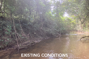 Lower Mud Creek Restoration Project, Hendersonville, NC
Technique: removal of berms and levies to reconnect the stream with the floodplain
In 2002, the City of Hendersonville acquired two historically agricultural parcels near downtown to serve flood reduction and stormwater benefits along Mud Creek, which is on the 303(d) list for water quality impairments. Wildlands assisted with a planning study and subsequent grant funding requests to remove relict agricultural berms and complete stream, floodplain, and wetland restoration efforts. Similar to raising incised streams, removing berms and levies or setting back levies can reconnect streams with natural flood storage on the floodplain. Wildlands also helped pursue funding for a 25-acre acquisition of a low-lying parcel that planning efforts identified as a key parcel for flood storage and park and greenway connectivity. Mud Creek and its tributaries are flat, and part of the project’s challenge is understanding the complex urban hydrology of the sites. An extensive network of stream and wetland gages has been deployed to support the validation of two-dimensional stream and flood flow modeling to make modifications that will benefit ecological and flood reduction efforts while preventing any unintended consequences to the dense urban infrastructure network near these future City parks.
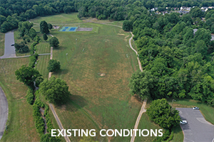 Bethel Park Stream Restoration Project, Morganton, NC
Technique: expansion of floodplain bench to reconnect the stream with the floodplain
Bethel Park encompasses approximately 15 acres within the eastern portion of the City of Morganton (City), NC. The Park provides direct recreational opportunities to adjacent neighborhoods and is one of the most frequented parks in the City. The perennial streams of East Prong Hunting Creek and Fiddlers Run serve as the boundary of the Park, to the east and west, respectively. Both streams are on the 303(d) list and are impaired for fecal coliform. Under normal rainfall conditions, flooding reduces the recreational use of the various amenities within the Park. Sediment deposition and standing water adversely impact access and use of the existing walking trail, limit usage of the existing dog park, and facilitate the growth of nuisance vectors (mosquitoes) within the Park. Additionally, the Park has limited conveyance capacity, resulting in large amounts of standing water for extended periods after rainfall events. This limits the City’s ability to maintain the grounds, resulting in excessive vegetation growth, a reduction in the usability of the Park’s amenities, and an impairment to its aesthetic qualities.
The Bethel Park Restoration Project was developed to mitigate nuisance flooding and increase Park function by restoring the degraded streams and reconnecting and expanding the existing floodplains below the existing Park grade. This approach will expand the riparian buffer, minimize maintenance activities, maximize utilization of the Park’s open spaces, and increase the functionality of the relocated walking trail during frequent rainfall events. Internal drainage and water quality improvements are met through the implementation of bioretention BMPs.
 Kings Grant Mitigation Site, North Charleston, SC
Technique: creating a buffer between rising tides and inland communities
Wildlands Engineering and Wildlands Construction recently restored a 41-acre tidal marsh in Charleston, South Carolina. This unique site historically supported a resilient and natural salt marsh but was acquired and developed into a golf course in the 1970s. In the mid-2000s, the site changed ownership again and was threatened by a proposed development plan prior to a strategic conservation acquisition by Open Space Institute. Due to its location in the estuary, the restored property supports a rare combination of intertidal brackish and saltwater wetlands, an imperiled resource. Tidal marshes are a crucial part of South Carolina’s ecosystem as both a habitat for many native species and a natural form of flood protection. As sea levels rise, the restored marsh buffers inland communities from storms and allows marsh habitat to change with rising water levels. Beginning in November 2022, construction consisted of clearing, grading, site work, site grading, channel construction, and planting. Final planting was completed in May of 2023, and the project will be monitored over the next five years to document vegetation establishment (growth), tidal inundation, and fish abundance and diversity.
 North Carolina Division of Mitigation Services’ Flood Resiliency Blueprint
Technique: multi-scale planning supporting watershed-scale and project-scale projects
Wildlands is involved in this project to provide expertise on nature-based solutions in the context of floodplain resiliency planning for future implementation. Wildlands is providing planning support for an online map-based tool that combines our design, geospatial, and planning expertise. In collaboration with the project team and with input from stakeholders, the blueprint tool for nature-based solutions will consist of watershed and site-level planning frameworks that support broad-level planning and targeting as well as site-specific project development. The tool will help communities identify options for protecting key infrastructure and addressing flood risk through conventional and nature-based solutions.
While no one project is a silver bullet to address the multitude of manmade modifications to the natural landscape, several projects, including stream, wetland, and floodplain restoration, stormwater management, and flood reduction and mitigation efforts along with vegetative restoration provide nature-based processes for stormwater management, habitat restoration, and flood reduction. With proper management, these projects aim to create largely self-sustaining systems that can manage heavy rains, support wildlife, and provide community recreational spaces.